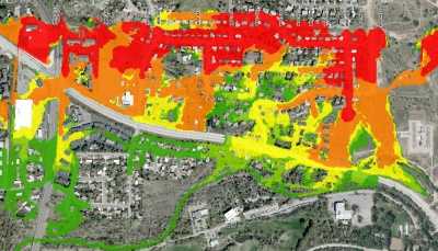
Penstock Breach Flood Routing
A client required an Emergency Action Plan (EAP) for the FERC licensing of a hydroelectric project in Utah. To develop the EAP, information is required on potential flood hazards downstream of the project penstock if a breach were to occur. WSE was retained to conduct hydraulic analyses to determine hypothetical breach discharges and to route those discharges downstream of the breach location.
Role / Services: WSE developed hypothetical breach flow hydrographs for numerous locations along the penstock. These hydrographs were then routed downstream using a FLO-2D hydraulic model. FLO-2D was used to simulate inundation depths, flood wave arrival times, and peak flow velocities over the landscape downslope of each theoretical breach. The modeling accounted for topographic features as well as obstructions created by structures in the flow path. More than 10 breach locations were investigated and a composite map of key hydraulic parameters (e.g. depth, velocity, time to flood) was produced.
Outcome: WSE provided analyses that were used in the development of the project EAP.
