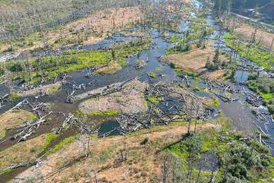
Monitoring Valley Reset Restoration on the McKenzie River and Quartz Creek
WSE was retained to monitor the ecogeomorphic and hydraulic evolution of two large restoration projects in the McKenzie river basin. Finn Rock, on the mainstem McKenzie, was restored to a river-wetland corridor condition in 2023, and Quartz Creek, a tributary to the
McKenzie, will be restored similarly in 2025. Both projects are being restored by resetting the valley bottom to a geomorphic grade line, which involves filling incised channels, excavating terraces, and adding massive amounts of in-stream wood. WSE is studying pre-project conditions and post-project evolution of this intensive restoration technique to understand its effectiveness and optimize future efforts to restore river-wetland corridors.
Role/Services:
- Monitoring wood dynamics and how wood influences geomorphic change
- Analyzing repeat topobathymetric LiDAR to track sediment erosion and deposition
- Analyzing geomorphic unit spatial configuration and diversity
- Creating calibrated, high-resolution, 2D hydraulic models to track inundation extent and predict floodplain inundation frequency
- Designing and conducting a targeted experiment examining how varying wood placement styles affect wood mobility, hydraulic function, and geomorphic function
- Synthesizing monitoring findings to provide actionable guidance for future restoration
Outcome: The project is ongoing. WSE has designed monitoring methods and helped write grant proposals to fully fund monitoring until 2028. WSE is currently collecting field data and creating initial hydraulic models.
