Aberdeen - Hoquiam North Shore Levee
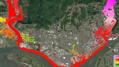
The Cities of Aberdeen and Hoquiam in Grays Harbor County are proposing to construct a levee along the Wishkah and Hoquiam Rivers and the harbor to provide protection from coastal and riverine flooding. WSE developed a HEC-RAS hydraulic model to inform the levee design and evaluate potential hydraulic impacts of the proposed levee. The hydraulic model includes approximately 12.7 miles of the Wishkah River, 5.5 miles of the Hoquiam River, 3.6 miles of shoreline along Grays Harbor, and overbank areas including the portions of the cities of Aberdeen and Hoquiam that would be protected by the levee. The model was used to determine whether the 100-year base flood elevation in this area is controlled by coastal (tidal) or riverine flooding. Base flood elevations and the design height of the levee were established and the model was used to evaluate the levee's impact on flood levels for the 100-year and 500-year events.
Role/Services: WSE developed a long term time series of tidal water levels and river flows for the Wishkah and Hoquaim Rivers and key tributaries. These were used as inputs to the hydraulic model of 18.2 miles of river and 3.6 miles of Grays Harbor coastline. A HEC-RAS 1D/2D model was configured for the project area to produce comparisons with the effective FEMA study. A fully 2D HEC-RAS model was then developed for use in hydraulic design of the levee. Model results were used to evaluate impacts of the levee on water levels. WSE then prepared mapping and reporting for a FEMA CLOMR submittal.
Outcome: The project is ongoing. A CLOMR application is being submitted to FEMA and WSE is working with the City and the design team to refine the levee design and address stakeholder questions and concerns.
